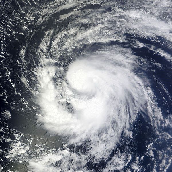
10 September 2011
Today, September 10, is the statistical peak of the North Atlantic hurricane season that runs annually from June 1 to November 30.
This year my friends and family have had more than their usual share of destruction from the few hurricanes that hit the United States. Hurricane Irene and the remnants of Lee have been headline news for weeks and Hurricane Katia, who’s missing the U.S. entirely, is affecting friends on a cruise in Greenland.
So I wondered… how and why do hurricanes form? I did a little research and found that even the basic facts are fascinating.
Hurricanes are tropical cyclones, complex dangerous storms that occur around the world. In the North Atlantic and on the eastern side of the Pacific we call them hurricanes. In the northwest Pacific they’re called typhoons.
Tropical cyclones are not completely understood but scientists know that six ingredients are required for a hurricane to form. The ingredients, listed at NOAA, are:
- A warm ocean surface of at least 79.7oF to a depth of 160 feet. To get an idea of how warm this is, the water temperature at the Eastern Maine Shelf this morning is 54-52o from the surface to 160 feet.
- Rapid cooling of the air as it moves upward, causing condensation and thunderstorms which release heat to drive the storm.
- High humidity in the mid troposphere 3 miles (15,800 feet) above the ocean. If you were on a trans-Atlantic airplane, you’d be flying high above it.
- The Coriolis effect must cause the storm to spin. There is no Coriolis effect at the equator so the storms cannot form at less than 50 of latitude (345 miles) from the equator.
- A pre-existing disturbed weather system near the ocean surface which provides the nascent storm with something to organize around.
- Low wind shear where the storm is forming. Wind shear is an abrupt difference in wind speed and direction and can break up a cyclone before it gets going.
In August and September hurricanes often form off the Cape Verde Islands near the north coast of Africa. They are then carried by the trade winds across the Atlantic and sweep over the Caribbean islands and sometimes the U.S. or Central America. Right now Tropical Storm Maria is heading for Puerto Rico and Tropical Storm Nate is about to hit Mexico.
Thank heaven we’re over the hump of hurricane season for 2011. We’ve certainly seen enough of them this year.
Learn more about hurricanes at NOAA’s Hurricane FAQ page.
(satellite image of Tropical Storm Katia from NASA’s MODIS Rapid Response System on 31 Aug 2011. Click on the image to see the original at Wikimedia Commons)
Had a course in meteorology 40! years ago exactly. I’ve always been interested in hurricanes.
First thing is the National Hurricane Center website is http://www.nhc.noaa.gov
I have a special page with lots of tropical weather links on my personal website at
http://roboftheriver.tripod.com/tropicalweather.html
There are lots of videos of Hurricane Irene Satellite loops on youtube. . .
One of the best, a closeup of the full life-cycle is here:
http://www.youtube.com/watch?v=cl9zJYms1X8
Another from a longer angle is here:
http://www.youtube.com/watch?v=LUStIT5aX7c
Last, but not least, I lived through Hurricane Agnes in June 1972 when I lived in Harrisburg for the summer, and we got out of town just before they closed the bridges!
Rob
LOL, I noticed that on your site it said that Tropical Depressions have no real damage. If I’m not mistaken Lee was a tropical depression by the time it got to PA and the flooding here has done a lot of damage. Of course, it doesn’t help when it comes a weak after another tropical storm, but I still think it’s kind of funny. We can be glad that this is the first active hurricane season since Katrina. We’ve had it really nice for the last 6 years.
Reply to Josh:
As far as TDs having no real damage, I believe you’re referring to the Saffir-Simpson Hurricane Scale table on my webpage, which refers primarily to wind damage. And while Lee never technically made it to PA at all, only rain bands generated by the upper and mid-level closed Low that resulted when Lee merged with a front, you’re certainly correct that rains from any tropical system can cause massive damage. Especially when they result in the kind of flooding that occurred when the winds on the east side of the closed Low generated such relentless rain bands coming up from the south pulling in moisture off the Atlantic Ocean.
I’m old enough to have lived through a lot of situations like this, and it always amazes me when people treat such tropical systems lightly.